Home / Guides / Tours & Activities
Natural Bridge Aruba: What’s Left and Is It Worth It?
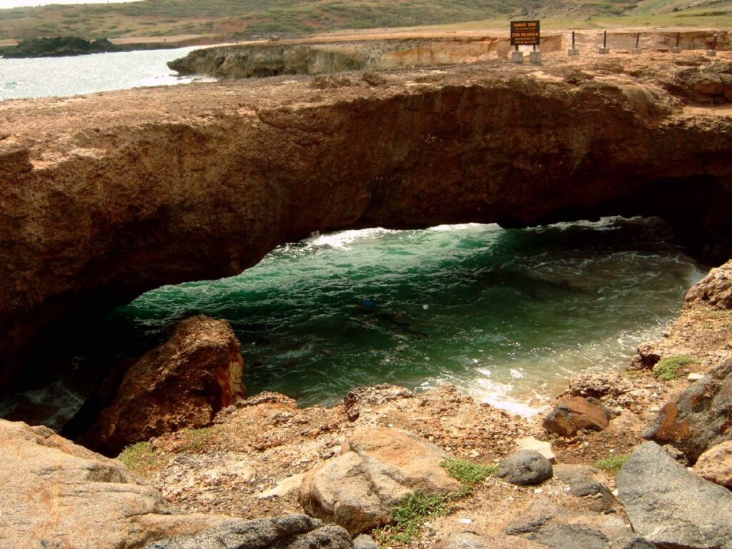
Search for Natural Bridge Aruba and most of the photos you find are from before 2005. The arch was once the island’s most photographed landmark: a coral limestone arch on the north coast, carved by the sea over centuries, big enough to walk across. On 2 September 2005 it collapsed. People still drive out to see it, and the honest question is whether it is worth the trip. My answer: yes, if you treat it as one stop on a north coast drive rather than the whole day.
Natural Bridge Aruba: what happened in 2005
The main arch stood roughly 7 metres above the water and stretched about 30 metres. It formed from coral limestone, likely the remains of an old cave, shaped by the pounding surf on Aruba’s windward side. That same surf brought it down. Today you see a pile of rock where the span used to be, with the sea still crashing through.
The Baby Bridge
Right next to the old site is the Baby Natural Bridge, a smaller arch that is still standing. It is solid enough that visitors walk out on it, though keep well back from the edges and away from wet rock. It is not the same scale as the original, but it gives you the idea, and the waves hitting it on a windy day are worth a few minutes on their own.
Facilities and practical details
- Location: the north coast, between the Bushiribana gold mill ruins and Andicuri Beach.
- Getting there: by car, 4×4 or on foot. The last stretch is on a dirt road, so go slowly in a normal rental.
- Facilities: a snack bar and souvenir shop sit near the site.
- Entry: I could not find a published fee for the bridge itself.
- Shade: very little. Bring water and a hat.
The north coast takes the full force of the north-east trade winds. Do not climb down to the water, and keep children close on the rocks.
Make it a north coast loop
The bridge is better as part of a short circuit. Here is a route that works in a morning:
- Alto Vista Chapel: Aruba’s first chapel site, a small yellow church above the coast.
- Bushiribana ruins: a stone gold mill from the 19th-century gold era, a few minutes along the coast. You can climb up inside for sea views.
- Natural Bridge and Baby Bridge: a short drive further along the dirt road.
- Ayo Rock Formations: giant boulders inland with old rock drawings. Frommer’s lists free entry, open daily from morning to late afternoon.
- Donkey Sanctuary: close to Ayo, if you have kids or carrots.
More about the stops along the way
Bushiribana gold mill
The stone ruin on the coast is what is left of a gold smelter built by the Aruba Island Gold Mining Company. Frommer’s dates it to 1872 and says it ran for only about a decade. Ore came down from the hills around Sero Plat. The thick walls look almost like a fort, and you can climb up through the levels for a view of the surf.
Ayo Rock Formations
Huge diorite boulders piled inland, with reddish-brown rock drawings left by early inhabitants. Frommer’s lists the site as free and open daily from 9:00 am to 5:00 pm. Do not climb on marked rock art areas.
Andicuri Beach
The beach the old bridge stood beside. Like the rest of the windward coast, it is better for looking than for swimming.
Seeing it on a tour
If you do not want to drive the dirt roads, several tours stop here. De Palm’s UTV route includes the Baby Natural Bridge, and ABC Tours lists the Natural Bridge on its full-day jeep safari. Tours keep you moving, though, so if you want time to sit and watch the waves, drive yourself.
Aruba’s other natural bridges
The main bridge was not the only one. Aruba’s tourism board points to several smaller arches around the island, including one at Wariruri on the north coast, a tripod-shaped bridge near Black Stone Beach in the south, and others in Arikok National Park and near Seroe Colorado. UTV and jeep tours often stop at Wariruri and the Baby Bridge, so if you are on a tour anyway, you will likely see them.
What to bring and when to go
- Morning is best. It is cooler, the light is softer on the rock, and you beat the tour convoys.
- Closed shoes. The coral limestone is sharp and uneven.
- Water and a hat. Shade is scarce once you leave the snack bar.
- A dust cloth for the camera. The wind carries fine sand and salt spray.
- Respect the edges. The 2005 collapse is the clearest reminder that this coast is still being reshaped by the sea. Stay off overhangs and wet rock.
Is it worth it?
Go if you want to see the wild side of the island, the side without resorts. The drive along the coast, the ruins and the waves are the real attraction. Skip it if you have one day and want to be in the water: the north coast is for looking, not swimming. In that case, spend the morning on the calm west side and save the coast drive for another afternoon.
| Good for | Not great for |
|---|---|
| Photos of big surf | Swimming or snorkeling |
| A half-day self-drive | Anyone who hates dirt roads |
| History and geology buffs | Midday heat without shade |